Search with words
Search with an image
Search with voice
Describe what you want
Describe what you want
Speech recognition not supported
Your speech...
Your speech...
images & artists
images only
Drag or upload an image here
Your images are not stored. All search activity takes place on our own servers.
Artists
Connecting You to a World of Illustration
Illustrators
Styles
Search by
Text
Voice
Image
USA
USA
UK
France
China
Australia
Brazil
South America
India
Germany
SE Asia
Japan
Korea
1-646-808-0205
|
inquiries
Kate Snell
UK
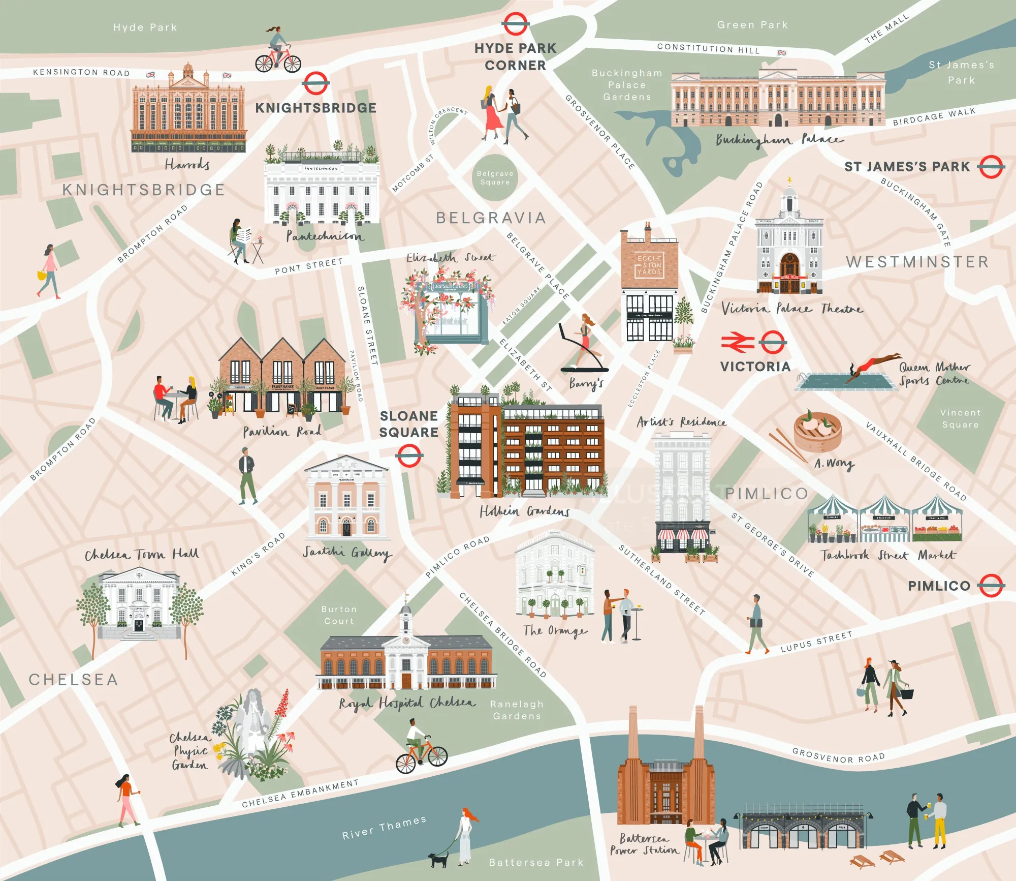
Illustrated Map of Central London Districts
Colorful illustrated map showing central London areas and landmarks, including Hyde Park, Belgravia, and Chelsea.
More like this
Keywords
Architecture
Buildings
Computer Generated
Flat Color
Maps/Graphs
Want to discuss a commission?
email
call
Speak to a local agent
1-646-808-0205
Similar illustrations by Kate
Browse by style
/
Categories
/
Media
3D / CGI Rendering
Advertising
Animals
Animation
Anime
Architecture
Beauty
Black & White
Book Covers
Botanical
Cartoon & Humor
Character Design
Children
Collage & Montage
Coloring Book
Comic
Conceptual
Cute
Decorative
Editorial
Educational
Fantasy
Fashion
Fashion Luxe
Food & Drink
Gaming
GIFs
Graphic
Historical
Icon
IG Influencers 10K +
Infographic
Jewelry
Lettering
Lifestyle
Line
Live Event Drawing
Loose
Maps
Medical
Nature
New Talent
Packaging
Painting
Paper Art
Pastiche
People
Photorealistic
Places & Locations
Pop
Portraits
Retro
Seek & Find
Sport & Fitness
Storyboard
Street Art & Mural
Technical
Vector
Watercolor
Wood Engraving & Etching
Young Adult
animation styles
/
Categories
/
Media
Children
GIFS
Explainers
Motion Graphics
2D
3D
Stop Frame
Animated (animated by others)
Do you commission animation as well?
If so, we represent many outstandingly talented animators, creating gifs, explainers, characters, stop motion and motion graphics for TV, film, games and digital streaming in 2d and 3d.
Other offices
:
France
Germany
Brazil
South America
China
Australia
SE Asia
UK